Pages

Showing posts with label urban design. Show all posts

Saturday, 27 October 2018

Sejong Smart City Design Competition


Urban Design Studio for postgraduate students at ERICA Campus, Hanyang University, led by Networking City, is invited for the student design competition of ‘Sejong Smart City’ by Korea Land & Housing Corporation (LH).

Last January, Ministry of Land, Infrastructure and Transport of South Korea designated ‘5-1 Liveable Area of Sejong City’, a part of the new Korean administrative city, as a national testbed for Smart City and LH took responsibility to create the smart city from an initial plan and design to delivery for 2.74 km2 area.

To promote the interest from academics, industries and citizens and to share various ideas, LH invites six urban design studios from Korean universities and supports them to do good projects. The urban design studios will suggest inter-disciplinary ideas and have a joint exhibition in December.

Networking City’s studio accepts the LH’s kind invitation and makes efforts to create a better urban environment.
More news about the competition will be followed. 

Tuesday, 28 January 2014

The techniques of urban design- Designing Cities: Basics, Principles, Projects


Image 1. The book cover of ‘Designing Cities: Basics, Principles, Projects’
 
What is the basic knowledge for urban design? Which techniques are necessary for designing decent urban spaces? ‘Designing Cities: Basics, Principles, Projects’, written by German architect Leonhard Schenk, is navigating the answer of these questions.
The book is structured along three parts,
1) General principles of urban design
2) Practical techniques for designing cities with relative examples
3) Three sensible examples that are recently constructed and well evaluated   - Hamburg (Germany), Tubingen (Germany) and Belval (Luxemburg)
When people want to make an overview from the basic theory to the completed projects, it seems a well organised book to look through all parts. 
 
The author argues that the most urban design projects have been realised by competitions, and two factors should be incorporated to win the competitions. On the one hand, projects need to satisfy the demands of the client and the jury. On the other hand, the functionality, the design and the representation capacity of projects have to be promoted by themselves. This argument clearly indicates the direction of the book. Over 350 pages, the author illustrates in detail the systematic methods for creating urban spatial organisations and visually attractive designs.
 
What an interesting point of this book is the explaining principles of urban design step by step, particularly in the Chapter 1 and 2. For example, ‘the law of similarity’ describes that ‘elements that resemble one another in the form are more readily experienced as belonging together than elements are. In addition, similar elements result in more uniform groups than dissimilar ones’. (P.21, See image 3) The principles demonstrate not the characters of each element but the natures of the group as a corporate body of the elements. These rules are underestimated because too simple and too obvious. But, we could easily deep in troubles during the design process if we do not keep them in mind. And then, from the Chapter3, the author starts to explain the practical ways of urban design such as designing urban blocks, various grid structures, organising building lots, road systems, designing public space and representation skills. 

Friday, 26 July 2013

Free Range exhibition & Welsh School of Architecture Exhibition


Image1.Free range Exhibition place. The image was taken by Networking City

FREE Range exhibition had opened its door at Truman Brewery on Brick Lane where is a cultural headquarter of London. This exhibition was for undergraduate courses of fashion, design, photography & media, fine art and interior & architecture over the UK. It was started in 2001 and has been getting a reputation for one of famous cultural event in London. In this year, fashion courses kicked off their exhibition from May 31and interior & architecture courses ran its show from June 11 to 15. Twenty five universities across the country, including Glasgow, Dundee, LCC, Westminster and Manchester, set up their own booths and unfolded their ideas, talents and capacities. The universities might want to get a chance to show off their students into the largest market London in this disastrous recession.


Image2.Free range Exhibition place. The image was taken by Networking City


Image3.Free range Exhibition place. The image was taken by Networking City


Image4.Free range Exhibition place. The image was taken by Networking City


Image5.Free range Exhibition place. The image was taken by Networking City


Image6.Free range Exhibition place. The image was taken by Networking City


Image7.Free range Exhibition place. The image was taken by Networking City

 The works of Welsh School of Architecture (WSA), Cardiff University was awesome and highly recommended from many architects who work in London. Although it is hard to compare directly to other universities because WSA exhibition consisted by the projects of masters’ students while others were bachelors’, seven units of WSA might not fall behind other schools in London. In fact, WSA was ranked as the second best department in GuardianUniversity Guide 2014 and they marked the same position with AA School in the list of the UK best architectureschool surveyed by Architects' Journal.

 
Image8.WSA Exhibition place. The image was taken by Networking City

Image9.WSA Exhibition place. The image was taken by Networking City

Image10.WSA Exhibition place. The image was taken by Networking City

Image11.WSA Exhibition place. The image was taken by Networking City

Image12.WSA Exhibition place. The image was taken by Networking City

 
Image13.WSA Exhibition place. The image was taken by Networking City


Image14.WSA Exhibition place. The image was taken by Networking City

 
When it comes to me, the works of ‘Unit 7: Infrastructural Urbanism’, which explore reorganizing local identity in the process of changing urban industries, were particularly impressive. Usually, when we proceed urban design projects, we start first to overview macro urban structures, its development history, and regional issues and so on. Then, we reach the level of urban and architecture design what should make balances between abstract urban policy & specific physical design, macro urban patterns & micro human behaviours and economic feasibility & public value by design quality. At this point, lots of conflicts would be emerging, and it should be hard to reach agreeable point. Furthermore, when the work frame is changed such as from urban design to architecture design, logical connections between different types and scales of works would be weakened. We can say it as ‘logical jumping’. Networking City understands Unit 7 admitted the jumping could be appeared, however; they might try to know what the jumping would be there and how they could minimize the jumping at each development phase.

Elizabeth Venning’s work, Supportive infrastructures: Affordances between the DVLA and its locality at different scales, which examines new possibility of massive district of DVLA (Driver and Vehicle Licensing Authority) in Swansea City, well shows the characteristics of this unit. She investigates the way of redefining the physical and social relationship between DVLA area and local people through transforming and reorganizing some DVLA’s buildings and its programmes. In order to provide an effective strategy, she finds that there are six different levels including National scale, Regional scale and Household Scale behind the integrated complexity and each level has relevant policies, rules and orders that impact on the site. All policies, rules and orders at each level are analysed by Venning, and inter-relationship between levels and response plan are proposed with building plans in detail. 

If you want to know more about Welsh School of Architecture and their exhibition, please visit this link.

Image15. Elizabeth Venning’s work. The image was taken by Networking City
 

Image16. Venning’s diagram shows six different systems of the site. The image was taken by Networking City
  
Image17. Models and panels of WSA. The image was taken by Networking City


Monday, 25 March 2013

Review: City Sense - Shaping our environment with real-time data


Image1. The cover image of ‘City Sense - Shaping our environment with real-time data’
Since 2005, the Institute for Advanced Architecture of Catalonia in Barcelona, which is a provocative architectural school and research institution, has opened architectural competition once in every two years. This competition seeks new types of architectural experiments in the fast changing urban environment and is gaining an international reputation over the world. The most recent competition was held in 2011, and 275 groups participated in from 98 countries. The themes of the competition have expected ideal projections in the future rather than current urban situations; therefore, it is a bit harder to articulate architectural ideas of the themes than other competitions.
 
The book “City Sense - Shaping our environment with real-time data”, which was published by ACTAR, is the outcome of the competition in 2011 and the title of the book is the same as it of the competition. 
 
High speed information and communication technologies have created more possibilities of diversity, mobility and change in the city that comparatively the speed of change is lower than the speed of the technologies by its physical nature. Therefore, urban design and urban planning in the future would claim not traditional approaches for physical urban structure but more and more concerns of immaterial and invisible urban factors based on the development of the technology. In the preface of City Sense, Manuel Gausa, Dean of IAAC, argues that new urban dynamics will emerge from interactive, synchronous and integrated information in multi-level of urban areas, not physical characteristics any more. He explains the purpose of this competition was to find innovative ways of urban design for increasing civic participation, interactive response with the urban environment and real-time information. 
 

Image 2. page 76-77. Honourable Mention- THE DATA-CITIZEN DRIVEN CITY

Image 3. Second prize winner- THE CYBORG LANDSCAPE
 
Image 4. Third prize winner- RCNHA 2030+


Image 5. Honourable Mention- 0kWhcity

 The publisher divided competition entry works into six categories: Sensors & Data, Adaptive & Reactive, Behavioural systems, Parametric technology, Social & Collaborative and Theories & Strategies. There are many fresh and fascinating ideas to show various approaches to architectural and urban design. For example, enhancing digital networks in urban areas by social media and applying to urban management, reducing the rate of risky incidences of Chicago through making 1/25 scale testing model of Chicago, creating on-offline network for exchanging second-hand goods and suggestion for architectural system to checking environmental pollution in the site of landfill.

Among lots of entertaining works, Francisco’s work, which is the first prize winner, is outstanding. Francisco Castillo Navarro is an architect and interactive designer. After he graduated from ETSAS and UPF, he set up his own research group: Responsive Environments and has been doing several research projects focus on the urban environment changes.


Image 6. pp.82-83. First prize winner- CITY DATA SENSING


Image 7. Panel image of CITY DATA SENSING
 
His idea is to collect invisible but influential data for urban life such as the flows of energy, transportation and economic, and to provide these data with citizen based on real-time. It leads the change of citizen activities and then new information are generated by these changes, as the result, the citizen and the information in urban endlessly foster the interaction between them.
The most participants are bound in physical architectural suggestions as the outcome of the competition; however, Francisco illustrates that integrated system for real-time information, which would stimulate sustainable interactive actions of citizen, could become an aggressive outcome of urban design in the digital era. Unlike other entry works which started from architectural ideas, his approach began from the other fields such as collecting real-time data, visualisation of big data and urban modelling. His final images for the competition could be understood as pretending to describe multiple urban data; however, his actual final work is a movie file to display collecting urban information on tidal system and visualising it.  As the result, other participants demonstrate images and systems at the moment; however, Francisco’s work suggests that the tidal changes of urban information and the visualising structure of real operating situation. Please check his movie image here.  On his blog pages, there are nice information of 3d printing and robotic fabrication as well as his works. Blog1 and Blog2. 
 
The new book of ACTAR is too full of suggestions to regard just the outcome of idea competition. Above all, this book clearly points out that new urban environment based on the rapid developing technologies pushes architects need to collaborate with other fields more than before. It reminds us to consider how the urban environment will be changed by integrated set of information from individuals and institutions, and how new technologies impact on architecture.
Secondly, all winning projects of the competition propose specific own urban system connecting with all urban area not separate buildings. Traditional design approach, which means the sequence of analysing site, finding similar cases, making concept idea, developing mass and building up 3d model, cannot be available anymore for new urban design that needs to understand and develop urban networks and its system.
 
Of course, there are some disappointing parts.
All participants submitted three panel images through the internet, but it is doubtful whether traditional panel images would be applicable to explain invisible flow of data in urban areas or not. As we regard that the real outcome of the first prize winner is a movie image, IAAC needs to revise the format of the submission. On the one hand, there are many fresh ideas and well finished projects. On the other hand, I think the most projects are not far away from pre-existing design methods and are rooted in technical optimism that the city could be effectively controlled by one system. Also, the size of the book is relatively small. It is convenient to carry, but uncomfortable to look at images.
 
But it is obvious to allow this book as a good reference to designate the influence of the technologies on the city and alternative ways of urban design in digital era.
 
The detailed contents and the entry works of last competitions are well arranged on the homepage of IAAC. Please visit there.  
1st competition- Self-Sufficient Housing, 2005http://bit.ly/YMF79q
2nd competition- Self-Sufficient Housing, THE SELF-FAB HOUSE, 2007http://bit.ly/WphN53
3rd competition- THE SELF-SUFFICIENT CITY: Envisioning the habitat of the future, 2009http://bit.ly/13zxrgk
4th competition- THE SELF-SUFFICIENT CITY: Envisioning the habitat of the future, 2011http://bit.ly/Crab7
 

Basic outcome is below.

Paperback: 368 pages
Publisher: ACTAR / Institut d'Arquitectura Avançada de Catalunya (IAAC)
                 (2 Jan 2013)
Language: English
ISBN-10: 8415391293
ISBN-13: 978-8415391296
Product Dimensions: 16 x 12.2 x 2.3


Friday, 8 March 2013

BSP Seminar - Compact cities or garden suburbs?


Dr. Nicolas Falk presented for Bartlett School of Planning. Image is taken by Networking City

In this year, Bartlett School of Planning run BSP seminar series over the semesters. On 6 March 2013, Dr. Nicolas Falk, Director of URBED (Urbanism Environment Design), provided a presentation the title of “Compact cities or garden suburbs?” at Central House of UCL.

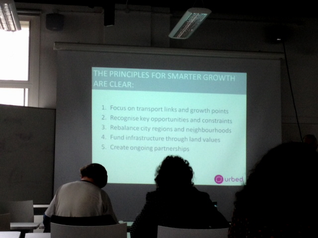
Because I was bit late, I could not watch all his presentation. He suggested simple but well-summarised planning keywords and showed relevant examples over the European cities. For example, he argued there are five key elements to reach Smart Growth. The five keys can be represented as 5C: community, connectivity, character, climate and collaboration. And he mentioned the meaning of the community with examples such as  ‘Schools as community hub with Houton, NL’ and ‘Places for all ages with Reiselfeld, Freiburg, Germany'.

Connected city, Five finger strategy and Redefining Greenbelt were mentioned as the future direction for smart growth in the UK as the conclusion of the lecture. In particular, he had expressed the negative feeling against current Greenbelt policy. According to him, the greenbelt of London is little bit old-fashioned and the greenbelt has been a strong obstacle to expand development areas and connecting between London and other cities. Although he said Redefining Greenbelt as one issue of the future direction, all three items should be accompanied with the reorganisation of London’s greenbelt. 

During his lecture, some questions were emerging by myself. Is really Green belt the obstruction of smart growth? Is there smart growth? If possible, how are different process and method needed compared to typical urban development? How can it work in high density?

I think there are two reasons why the questions were come up.
In the first, he emphasised the term of ‘smart’ and ‘smarter’ several times in his lecture. However, the term, smart, has been considering with the development of technology in our built-environment while his suggestions and examples were more familiar with sustainable urban planning and design.
Secondly, the key issues what he argued are too abstract and vague. We know community, connectivity, character, climate and collaboration are crucial factors. People might want to listen from him how we can achieve those factors, what kind of process, the roles of stakeholders and so on.

One of his lecutre slide. Image is taken by Networking City

There are good materials of urban design, field research and regional study on the homepage of URBED. They have run urban design and architectural design studios at University of Sheffield, so we can find the links of interesting students’ works. Also, they published ‘Sustainable Urban Neighbourhood’ in 2010 what includes some contents of today’s lecture.
 

Friday, 22 February 2013

Review: Basics Landscape Architecture 01: Urban Design


Cover page of Basics Landscape Architecture 01: Urban Design
When I was an architectural student for my bachelor, nobody told me and taught me about urban theory and urban design. And it became the main reason why I started to learn urban studies in London after some years. 
When I attended the first design class for designing house and small building in the school, professors pushed us to consider the meanings of architecture and home, the difference between public space and private space, the characteristics of users, design methods and so on. Several good references were introduced as well.
However, the next semester after the house design, still I had not enough to finalize one mass or one building, I was thrown into ‘urban’ and had to design the building in the context of urban and urban itself.   
In the beginning, it was very exciting to make something new in large and complex area by myself. But, in an instant, I realized it is really difficult to distinguish what I have to consider, how I analyze urban aspects, how the aspects could be led to design materials and what urban really is. Nobody told me and it was hard to find something what exactly explains the way of urban design. Furthermore, the embarrassment by jumping into large scale from small level was tantamount to facing a great wall.
At that time, I was thinking that ‘Is there any readable book to show the guideline of urban design?’. I believe other people who studied or have been studying urban design at the department of architecture might suffer similar experience with me.
 
‘Basics Landscape Architecture 01: Urban Design’ from AVA Publishing should be a good reference for people who have the same problem what I had before. This book is composed of six chapters: What is Urban Design?, Context, Measure, Movement, Community and Culture, Projects and Processes. Each chapter provides the meaning of the title, summarizes main issues and spreads out relevant examples.
Like other basic series of AVA Publishing, it provides general knowledge of urban design with core issues, key individuals and good design examples for beginner, rather than deep-abundant thought for broader discussion. 
In fact, many elements of the contents are complicated and vague to define each meaning and suggest compatible cases; therefore, the frantic effort of the authors which translates to comfortable language would be respectable.
 
Page 20-21: Evolution of urban form


For example, this book sums up urban growth as a chain of events : clusters of dwellings – City walls – Sprawl – massive growth in the industrial age – new urban forms (even it would be too simplified), and the authors argue that recent urban growth should be focused on not physical land expansion but social facts such as international migration. 
 
The best point of this book is to excite curiosity of readers and stimulate finding key issues, individuals and cities. In my case, I took an interest again in grid system which is the oldest method of urban design. Grid system has been developed since Ancient Greece and was intensely used by Roman Empire. It was not just a tool for construction of new city but a symbol of their domination over nature as well as imperial power. Personally, I have been interested in the grid structure of cities such as Barcelona, New york and some Korean modern cities. After reading the part of the grid, ‘The City Shaped: Urban Patterns and Meanings Through History’ was borrowed from library and unfolded additional texts.    

 
Page 143: Structure-Barcelona Grid
 
 Also, the book mentions how urban elements can be developed as the main design concept and how it leads the project. The last chapter of the book, Projects and Processes, introduces five basic elements of urban design: Structure, Line, Point, Beyond and Green, and briefly provides some examples. In the case of Line, the authors insist that lines in urban projects occasionally represent the movements in urban areas. Complex urban scenarios and expanding urban movements in cities can be organized by infusing conscious lines into the projects such as the cases of Barcelona, New York and Hong Kong.


Page 148-149: Case Study-High Line

 
Page 150-151: Case Study-Euralille
 
Total 170 pages with many images is not a big burden as the first step of urban design, so the book is recommendable for students who just started studying urban design such as 3rd year or intermediate course students.  

Basics Landscape Architecture 01: Urban Design
Paperback: 184 pages
Publisher: Ava Publishing (Oct 2009)
Language: English
ISBN-10: 2940411123
ISBN-13: 978-2940411122
Product Dimensions: 16 x 1.7 x 23 cm